Top 5 Hikes in Madeira (2026): Full Guide with Maps and Tips
If there’s one thing Madeira does better than dramatic coastline views and addictive bolo do caco, it’s hiking. This island is basically one massive trail network disguised as a holiday destination. From ancient levadas winding through laurel forests to narrow cliffside paths that’ll test your nerves (and your knees), Madeira is a hiker’s dream.
But, hiking on Madeira isn’t as simple as showing up and following a sign. Some trailheads are in the middle of nowhere, parking can be chaotic, and trail closures are a real thing due to weather or maintenance.
That’s why I put together this Madeira hiking guide, it’s not just a list of “pretty hikes”, but a full-on breakdown of five incredible routes with practical info I wish I had from the start. I’ll cover where they begin, where they end, how to get there (with or without a car), trail routes, parking options, difficulty level, and what I personally loved, or struggled with, on each one.
If you are lost between all the options to hike on Madeira and you don’t have all the time in the world, below are the top 5 best hikes on Madeira that you can visit and get a great feel of the island.
This article contains affiliate links, which means that if you book accommodation, a tour, or a service through them, I may earn a small commission – at no extra cost to you. It helps me keep creating free content. Thank you for your support! 😊
Find more travel guides and articles for your next trip right here.
PR1: Pico do Arieiro
Trail Overview
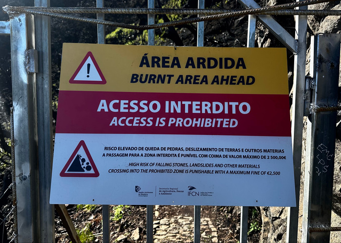
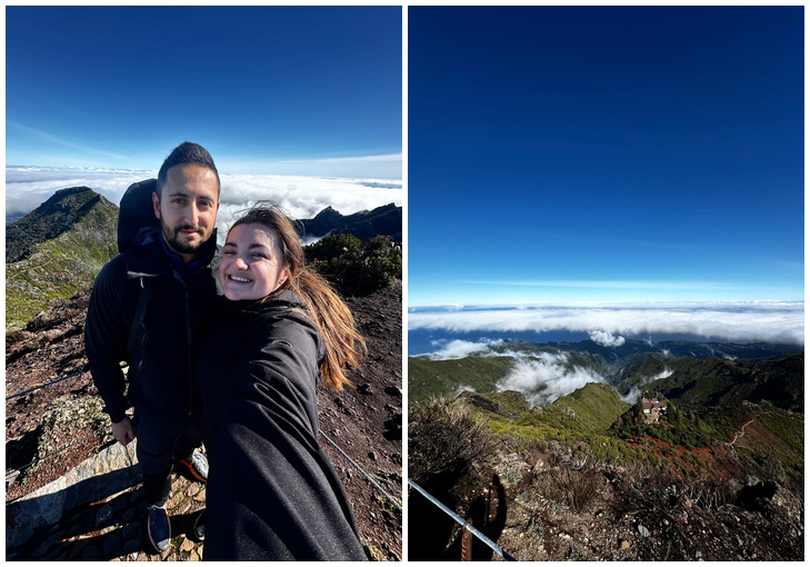
This trail is famous for its spectacular views and is by far the most iconic hike on the island, leading to Madeira’s highest peak, Pico do Ruivo (1861 m). Unfortunately, when we went (May 2025), most of the trail was closed due to fire damage. Still, even if you can’t complete the full hike, it’s absolutely worth visiting.
The section that was open was around 1.2 km long, but even at the very beginning, you’re met with incredible views of the surrounding mountains and clouds below your feet. The path is paved the entire way and there’s a railing you can hold on to. I wouldn’t call it dangerous, but the views are definitely dramatic. Just take your time and enjoy it. Personally, I wasn’t super comfortable, I’m afraid of heights, but I know most people won’t have that issue.
If you want to avoid crowds, come super early for sunrise or in the evening for sunset. We went in the late afternoon, hiked the open section, and watched a sunset that completely blew us away.
Madeira’s weather is unpredictable, it’s not unusual to experience all four seasons in one day. It’s hard to say what the conditions will be like at the top; sometimes you arrive and find yourself surrounded by dense fog with zero visibility. That’s why I’ve included links below to a local weather forecast and a live webcam on NetMadeira from the summit, so you can check conditions a few hours before heading out.
If you’ve rented a car, there’s a good asphalt road all the way up to the starting point, and you only pay for parking. Parking is 4€ per hour, or 20€ per day.
If you haven’t rented a car, your best option is to book a trusted tour. A driver will pick you up from your accommodation, take you to the trailhead, and pick you up again at the end. The roads in Madeira are good, but extremely steep. If you’re not a confident or experienced driver, this is definitely the smarter choice.
Below you can check prices and availability:
Map of Pico do Arieiro Hiking Route - PR1
Full map with the trail for Pico do Arieiro (open part) and elevation you can find below:
Trail type ➡️ Out and back
Distance ➡️ 1.2km
Duration ➡️ 1hr
Elevation ➡️ ~1,000 m (for full trail)
PR6: 25 Fontes and Levada do Risco
Trail Overview
This was the first trail I did in Madeira, and it’s best known for its beautiful waterfalls and lush greenery. You’ll slowly descend through the forest towards the 25 Fontes and Risco waterfalls, all while enjoying the peaceful atmosphere of the levada paths. I cannot even describe how soothing are the sounds of levadas on this trail.
Halfway down there is a restaurant/cafe where you can take a rest, drink coffee (non-negotiable for me) or grab a quick bite.
It’s perfect for nature lovers and anyone looking for a slightly easier hike. The path down to the main waterfall is mostly a gentle descent, but the return is definitely tougher. Still, nothing too intense. Overall, it’s not a demanding trail, though there are some uphill sections on the way back
How to Get There
Parking is free along the dirt road (I’ve included the exact location below), but be careful. The ground is really uneven, and if you have a smaller car, you could easily scrape the bottom.
Map of 25 Fontes and Levada do Risco Hiking Route - PR6
Full map with the trail for 25 Fontes and Levada do Risco and elevation you can find below:
Trail type ➡️ Out and back
Distance ➡️ 9km
Duration ➡️ 3-4hr
Elevation ➡️ ~300 m (for full trail)
PR8: Vereda da Ponta de São Lourenço
Trail Overview
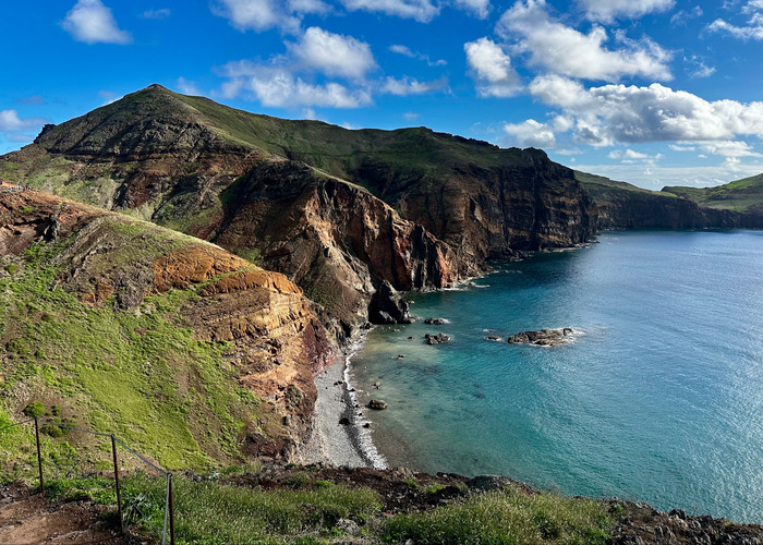
This trail on the eastern side of Madeira offers a completely different vibe compared to the rest of the island. Stunning panoramic views of ocean cliffs and green landscapes make it truly special. Honestly, I felt like I was walking through a scene from Lord of the Rings. It’s not too demanding, and that’s coming from someone who’s not exactly in top shape.
It’s easily accessible, and probably the most crowded trail I experienced on the island. There will be plenty of cars, so if you see an open spot a bit before the actual trailhead – take it. Trail is 3km long (and 3km back), so you can count on 2-3 hours to complete.
There’s a 3 euro fee that you can pay either by cash or card, and a couple of food trucks right at the beginning of the trail.
Map of Vereda da Ponta de São Lourenço Hiking Route – PR.8
Full map with the trail for Vereda da Ponta de São Lourenço and elevation you can find below:
Trail type ➡️ Out and back
Distance ➡️ 6km (3 each way)
Duration ➡️ 2-3hr
Elevation ➡️ ~470m
PR1.2: Vereda do Pico Ruivo
Trail Overview
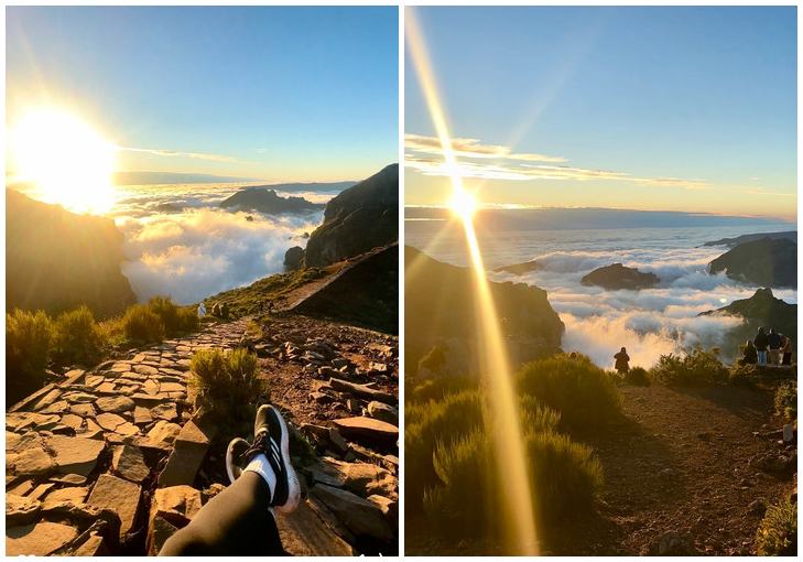
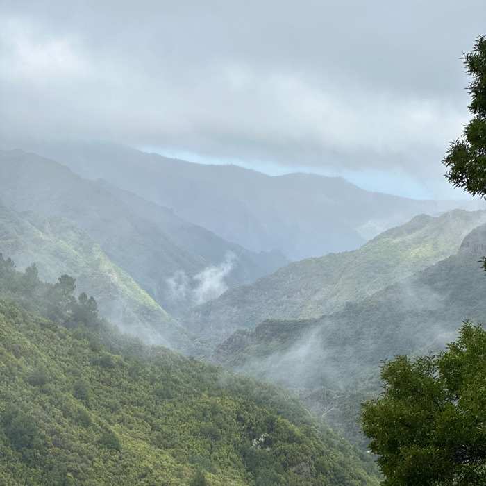
This is a really good alternative, especially since the PR1 trail is still partially closed (September 2025) and we still wanted to reach Pico Ruivo. It takes a bit more effort, but the hike up to Pico Ruivo is honestly one of the highlights of hiking in Madeira. From the top, you’ll have breathtaking views, with clouds literally beneath your feet.
We started the ascent from the parking area and greeted by fog and rain, we almost turned back right there, until the ticket guy at the entrance convinced us to keep going (and honestly, who wouldn’t be skeptical?). We hiked through mist, rain, and wind, with clouds rolling over our heads.
But the higher we climbed, the more we pushed through the clouds, and suddenly the skies opened up and we had a crystal-clear view above the cloud line. An unforgettable experience and a solid reminder not to rely too much on weather forecasts, because Madeira does its own thing.
The hike is a bit more physically demanding, but the path to the top is paved and very safe. Expect about 3 hours round trip.
There is 3 euro fee to access the trail.
How to Get There
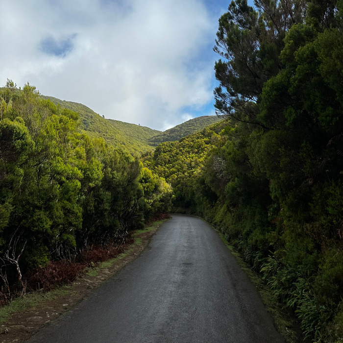
Easily accessible by car, roads are paved and plenty wide. Don’t remember it being too steep.
Here you can find availability for a Pico Ruivo sunrise tourwith a guide.
Map of Pico Ruivo Hiking Route - PR1.2
Full map with the trail for Vereda do Pico Ruivo and elevation you can find below:
Trail type ➡️ Out and back
Distance ➡️ 5.6km
Duration ➡️ 2.5-3hr
Elevation ➡️ ~350m
PR11: Vereda dos Balcões
Vereda dos Balcões is probably the easiest and most accessible trail on the island. It’s a short, flat 1.5 km round trip that starts in Ribeiro Frio and ends at a scenic viewpoint overlooking the Ribeira da Metade valley and the central mountains of Madeira. On a clear day, you can even see Pico Ruivo and Pico do Areeiro in the distance.
It’s perfect if you’re short on time, visiting with kids or older family members, or just want a “rest day” hike between the longer ones. The trail is shaded, paved, and well-maintained, no hiking experience required.
The only thing to keep in mind: if it’s cloudy, you might not see anything from the viewpoint, so try to come early in the morning before the mist rolls in.
How to Get There
There’s free parking available near the entrance in Ribeiro Frio, and the trail is well marked from the road.
Full map with the trail for Vereda dos Balcões and elevation you can find below:
Trail type ➡️ Out and back
Distance ➡️ 1.5km
Duration ➡️ 1hr
Elevation ➡️ ~50m
Final Hiking Tips for Madeira
Hiking in Madeira is incredible, as long as you know what you’re getting into. Most trails aren’t technically difficult, but the weather, remote locations, and logistics can make things more complicated than expected if you’re not prepared.
Start early, not just to beat the crowds and find parking, but because clouds often roll in by mid-morning and completely block the views. For trails like PR1 or Pico Ruivo, always check the forecast and a live webcam at least an hour before heading out. I’ve learned not to trust the weather apps too much. Madeira does what it wants.
Wear good shoes. A lot of trails are wet, muddy, and slippery, even when it’s sunny. Bring water, snacks, and layers. You can start in full sun and end up freezing and soaked. Always download offline maps just in case, signal disappears often. I use mapy.cz for offline trail maps.
And finally, if a trail is closed, don’t risk it. The island is beautiful, but it’s also wild, and there’s always another hike waiting.
These are the travel tools and services I genuinely use and recommend. They’ve helped me plan smoother, safer, and more affordable trips. Hopefully they’ll do the same for you.
Da bismo pružili najbolje iskustvo, koristimo tehnologije poput kolačića za čuvanje i/ili pristup informacijama o uređaju. Suglasnost s ovim tehnologijama će nam omogućiti da obrađujemo podatke kao što su ponašanje pri pregledavanju ili jedinstveni ID-ovi na ovoj web stranici. Nepristanak ili povlačenje suglasnosti može negativno utjecati na određene karakteristike i funkcije.
Funkcionalni
Always active
Tehničko skladištenje ili pristup je striktno neophodan za legitimnu svrhu omogućavanja korištenja određene usluge koju izričito traži pretplatnik ili korisnik, ili u jedinu svrhu izvršenja prijenosa komunikacije preko elektronske komunikacijske mreže.
Postavke
Tehničko skladištenje ili pristup su neophodni za legitimnu svrhu čuvanja podešavanja koje ne traži pretplatnik ili korisnik.
Statistika
Tehničko skladište ili pristup koji se koristi isključivo u statističke svrhe.Tehničko skladište ili pristup koji se koristi isključivo u anonimne statističke svrhe. Bez sudskog naloga, dobrovoljne suglasnosti od strane vašeg dobavljača internet usluge ili dodatnih zapisa treće strane, informacije sačuvane ili preuzete samo za ovu svrhu obično se ne mogu koristiti za vašu identifikaciju.
Marketing
Tehničko skladište ili pristup su potrebni za kreiranje korisničkih profila za slanje reklama ili za praćenje korisnika na web stranici ili na nekoliko web stranica u slične marketinške svrhe.


")
")

")

")

")
